
Represents the geological situation along the tunnel axis.
Characteristic |
Note |
Name |
Geological mapping in tunnel 001 |
Path |
\Tunneling |
Feature type icon |
|
Feature type class |
Regular |
Spatial data support |
Spatial support on observation |
Allowed spatial systems |
Axis |
Allowed geometries |
N/A |
Allowed contained feature types |
N/A |

Table 1: Characteristics of this feature type
Property structure for type specific feature data
This feature type defines not property structure for type specific feature data.
Property structure for type specific observation data
The property structure for type specific observation data of this feature type is a rich structure containing multiple collections. Figure 1 shows a graphical representation of this property structure.
|
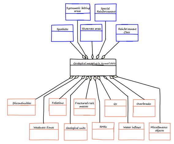
Figure 1: The structure of the type specific data for observations.
Property |
Description |
Engineering geological description |
General notes on the geology. Property type: String Validation rule: N/A Default Value: N/A |
Geologist |
Person who conducted (and is respoinsible for) the documentation of this observation Property type: Classification of type Geologist |
Serial number |
Assingining this number shall be done in a unique way on the server. Serial number is unique for each construction area (not unique across project) Serial number is an integer Serial number is not necessarily gap-free, or monotonous in any way but it is unique |
Geometry |
Defines location and shape of the mapping even Property type: Geometry Supported geometry types: Polygon, multi-polygon |
Table 2: Properties on level 0 of the Observations property structure of this feature type
