
This spatial system is used to specify location, shape and orientation (LSO) of a feature or observation on or near the surface of earth based on a horizontal geographic coordinate system and a vertical coordinate system.
In a geographic system the LSO of a real world object can be approximated by geometries based on points defined by latitude and longitude together with a reference to the used geographic system. Additionally to this geometry an elevation value can be stored. This elevation value is expressed in the vertical coordinate system that is used by this geographic system. Figure 1 shows how latitude an longitude are measured. Note that the position of the prime meridian is defined by the used horizontal geographic coordinate system.
The Application Server provides a predefined and non-modifiable list of supported horizontal geographic coordinate systems that can be used. The user can combine these predefined horizontal geographic coordinate systems with vertical coordinate systems to form a geographic system. See Table 1 for a summary of settings needed to define a geographic system.
Note that regardless of how coordinates of latitude and longitude are presented they are always stored as decimal degrees internally, i.e. even if the client or some presentation chooses to display coordinates of latitude and longitude in degrees, minutes, seconds and fractional seconds, the data on the Application Server will always store only decimal degrees. The necessary conversions might lead to (marginal) rounding errors.
Operations on geometries in a geographic system use angular computation to work out the result. These computations are based on the ellipsoid model of the earth defined by the horizontal geographic coordinate system. Note that - unless stated otherwise - the elevation is not used in operations done on geometries, i.e. all calculations are done as if the elevation was zero.
Additionally to the shape and the elevation value the Application Server allows to specify a height and a depth of a geometry. These values define the height above the given elevation and the depth below the given elevation value and can be used for an approximation of the real world 3D shape. E.g. if the geodetic geometry describes position and shape of a house, the height extent can be used to specify the height of the house the depth value can be used to define the depth of the houses foundations. The Application Server does usually not use this information in any geodetic calculations. Presentations might however use this information in 3D models.
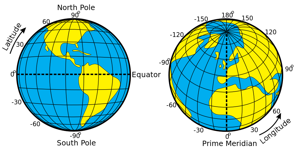
Figure 1: Latitude and longitude (source: Wikipedia)
Geometries used to specify the LSO of an object in a geographic system are restricted to geographies that cover less than one half of the Earth's surface. While this limitation will rarely affect you, it might produce an error when you define polygon geometries the wrong way. In the geographic system the LSO of a object is defined on a geodetic model of the earth, which is a continuous round surface. Unlike the projected system you can continue going in one direction and will get back to the point where you started. As a result a polygon definition in the geographic system must also tell which side of the polygon contains the area included within the polygon. The key rule to remember is that the area left of path that defines the polygon is included in the polygon, the area right to it is excluded. Therefore when defining a polygon in a geographic system be sure to define it counter clockwise.
In Redbex geographic systems are defined globally. Newly installed Application Server Databases include some predefined geographic systems. Some of these predefined systems are protected and cannot be modified or deleted by the user.
Setting |
Description |
Name |
Name of the Geographic system |
Description |
Description of the geographic system |
Horizontal coordinate system |
The used horizontal geographic coordinate system. This must be one out of the predefined list of supported horizontal geographic coordinate systems. |
Vertical Coordinate system |
The used vertical coordinate system. You can use any of your defined vertical coordinate systems. |
Table 1: Settings for a geographic system
