
The mapping page is a GIS like 2D representation of the construction area that allows you to view and modify mapping events and mapping objects.
Main user interface elements of the mapping page
Navigation bar
The iOS navigation bar on this page contains some important command buttons
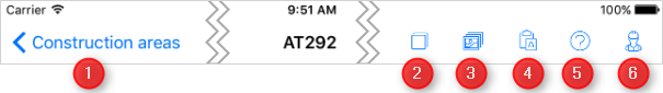
1: The Construction areas navigation link brings you back to the construction areas page.
2: Layers: Tapping this button will show the layers toggle window (and will automatically hide any other currently opened toggle window). The layers window allows you to define which information shall be visible on the map and which information shall be hidden.
3: Pictures: Tapping this button will show the pictures toggle window (and will automatically hide any other currently opened toggle window). The pictures window allows you to take pictures with your tablet device and store it with a reference to the currently selected mapping event or mapping object.
4: Attributes: Tapping this button will show the Attributes toggle window (and will automatically hide any other currently opened toggle window). The attributes is used for displaying and modifying the attributes for the currently selected mapping event or mapping object.
5: Help: Tapping this button will open the help topic for this page
6: Information pop-up: Tapping this button will open the information pop-up and your personal setting
Zoom buttons
The zoom buttons can be used to zoom in or zoom out. Alternatively you may also use a pinch gesture for zooming.

North Arrow
The North Arrow on the left lower edge of the mapping page shows the orientation of the map. Note the orientation of the map changes according to the selected detail area or active mapping event. When zooming to the extents of a construction area the Map will always be rotated so that North is in 12 o'clock direction.

Status bar
The status bar on the bottom edge of the mapping page will show some status information

Scale
The scale bar allows you to estimate the scale currently used on the map i.e. it allows you to estimate the size of objects.

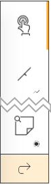
Primary toolbar
The primary toolbar on the left side of the mapping page is used to choose the tool you want to work with. The first command button on this toolbar is always the Selection tool. All other command buttons on this toolbar depend on the context.
Action bar
If a mapping object or a mapping event is selected an action bar will appear just below the Navigation bar. This action bar allows you to start actions on the selected objects.
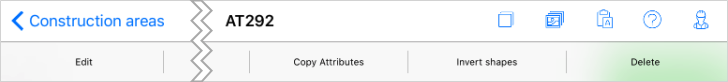
Figure: Action bar as shown for a selected mapping object with a line geometry, allowing geometry inversion.
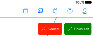
Finalization buttons
Some actions you perform on the mapping page must be explicitly finalized or canceled. In this case finalize buttons are shown. Finalize buttons can have different meanings in different contexts. The label on these buttons will clearly state what will happen if you tap this button in the current context.
Long-tap-menu
When you long tap on the map the mapping page will show a long tap menu. Depending on the context in which you are (i.e. if you have a detail area set or not) the menu will provide different options.
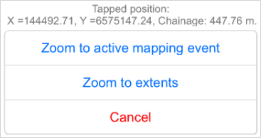
On top of the menu you will see the coordinates and the chainage at which you long-tapped to open the long tap menu. Below this you will see the available menu options.
Set detail area: Only available if there is no active mapping event. Will set the detail area around the tapped position.
Zoom to active mapping event: Only available if a mapping event is active. This will take you to the currently active mapping event and will zoom the map so that you see the extents of this mapping event.
Zoom to extents: Zooms to the extents of the whole construction area, and rotates the map so that North is at 12 o'clock.
Cancel: Close the menu
Gestures
Following gestures are available on the map when the Selection tool is chosen:
•Pinch zoom: Zoom in and out
•Swipe Pan: Tap and swipe to navigate on the map
•Long tap: Open up the Long-tap-menu
Note when drawing or editing a mapping object or mapping event these gestures are not available.
