
In the feature editor you can modify LSO of a feature or of observations. Depending on the used spatial system the window shows different spatial data controls for specifying the LSO. If the feature types spatial support is on feature the controls for specifying the LSO are shown on the base data tab, if the spatial support is on observation the controls are shown on the observations tab.
The spatial controls can be collapsed and expanded to save screen space (figure 1:1). To reset the values to null you can use the Eraser button in the right upper edge of the spatial data control (figure 1:2).
When the feature's spatial data is given in a projected or geographic coordinate system the data is presented as shown in figure 1 or figure 2. You can switch between these two presentations using the option buttons shown in figure 1:3. Selecting Point here will show the control as pictured in Figure 1:1 Here you can enter Easting (X), Northing (Y) and Elevation. The unit for Easting and Northing is the linear unit defined in the coordinate system. The unit of the elevation is the linear unit of the vertical coordinate system used by the coordinate system.
Selecting Geometry will show the control as pictured in figure 1:2. Here you can specify the geometry using WKT strings. For point geometries it is usually easier to just enter Easting and Northing however polygons, line-strings etc. can only be specified using WKT. Note that usually you will not manually enter WKT - you can use the shape definition window to graphically define the LSO of a feature or observation.
When changing the WKT string the Smart client checks if the string entered is a valid WKT if not a message will be written to the output window and the WKT will be rest to the previous value.
If the spatial system used by the feature is an axis reference system the spatial control pictured in figure 3 is shown. Start offset and End offset specify the interval on the axis reference system the LCS boxes specify the offset from the axis measured in the local coordinate system.
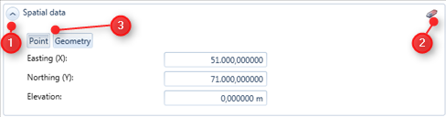
Figure 1: The control for specifying LSO's with a point geometry in a projected or geographic coordinate system
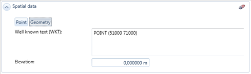
Figure 2: The control for specifying LSOs with a geometry given as WKT in a projected or geographic coordinate system
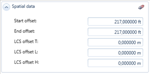
Figure 3: The control for specifying LSO's in an Axis Reference system.
