Redbex supports defining the location of features and observations using different spatial systems: geographic systems, projected systems, and axis reference systems.
A fresh installation of Redbex includes definitions for a few projected coordinate systems but you can easily create your own projected coordinate system.
For the mathematical definition of projected coordinate systems, Redbex builds on the widely used Cartographic Projections Library proj4. You can therefore define nearly any projected coordinate system.

Step by Step
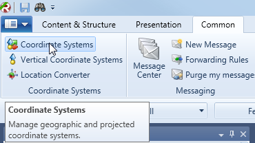
Opening the coordinate systems window
Creating a new projected coordinate system
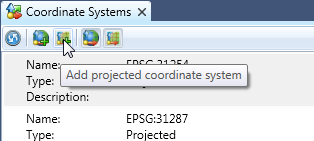
From the toolbar of the Coordinate Systems Window choose Add projected coordinate system. This will open a new window where you can specify all the details of the new coordinate system.
- Name: The name you want to display wherever the user can choose a coordinate system. Use a unique and descriptive name.
- Description: A description of this coordinate system. Add the details here that users need to understand which coordinate system this is.
EPSG Code: If your coordinate system is registred with the EPSG enter the number here. This is not mandatory but helps a lot when identifying coordinate systems. - Vertical coordinate system: Define which vertical coordinate system you want to use with this coordinate system. Note if you want the same horizontal coordinate system with two different vertical coordinate systems you will have to create two projected coordinate systems in Redbex.
- Linear unit: Give the abbreviation ot the linear unit used in this coordinate system. e.g. m
- Proj4 definition: Here you enter the real mathematical definition of the coordinate system in Proj4 syntax. We provide a listing of the proj4 definition of most EPSG registred coordinate systems in the document EPSG Coordinate Systems.

The coordinate system editor window
Additional reading
- Redbex Reference Manual: Read more how Redbex handles spatial data and projected coordinate systems.
- PROJ4 Documentation: Redbex builds on the mighty proj4 library for defining and transforming geographic and projected coordinate systems. The proj4 webpage proivides extensive information about how you can define all the projection parameters.
- EPSG Coordinate Systems: This document lists most of the EPSG registred projected coordinate systems together with their proj4 definitions.
- http://spatialreference.org/: A very good online resource for finding the definitions of spatial reference systems.